When a cloud of hot dust is thrown high into the sky by a big mountain of hot rock, it can be a problem for air ships that fly people around. Right now, we use space machines and special computers to work out how high the hot dust cloud is and to guess where it will go. This way can take too long for people who fly the air ships around. In our paper, we show a really quick way of working out how high the hot dust is. When the big mountains of hot rock throw the hot dust into the sky, they make a sound that we cannot hear but our special machines can. We can use this sound to work out how fast the hot dust is being thrown into the sky. With this, and a special number machine, we can work out how far they will go into the sky. Using the sound from a real hot mountain that threw out hot dust in 2009, we show that our way can very quickly work out how high the hot dust will go. Our way of working out how high the hot dust goes will better help the people who fly air ships around, and help people who watch the mountains of hot rock.
Confused? Let me explain. This is the abstract of my latest paper published in the Journal of Applied Volcanology, rewritten using the 1000 most commonly used English words. Even though it seems like it was written by a 5-year old, it was surprisingly difficult to do. Let me use the rest of this post to explain the work a little more sensibly.
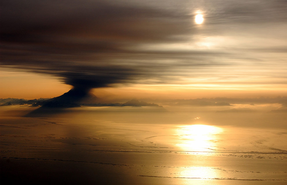 |
| An eruption of Mt. Redoubt as seen over the Cook Inlet near Anchorage, Alaska, on March 31, 2009. One of over 19 explosions from the volcano over the course of two weeks. Image source: Bryan Mulder/boston.com |
'Problems for air ships that fly people around.'
Most of us are probably fully aware that airplanes and volcanic ash do not go well together, especially after the 2010 eruption of
Eyjafjallajökull. That eruption alone cost the airline industry over
£1.1 billion (€1.3 billion, US$ 1.7 billion) in losses in only 6 and half days of disruption. In fact, it was not the first incident between planes and ash,
with nearly 130 incidents reported between 1953 and 2009. One of the most infamous incidents was in 1989 when a
KLM flight to Tokyo lost all four engines after it flew into a thick ash cloud erupted from Mt. Redoubt volcano in Alaska.
'Space machines and special computers'
The current system for monitoring ash plumes around the the world uses nine
volcanic ash advisory centres around the world. These centres use a combination of satellite observations and computer models to produce volcanic ash advisories. However, the satellites may take a while to pass over the ash cloud, and the computer models rely on poorly constrained parameters; not good enough for the enormous aviation industry.
 |
| Satellite image of Mt. Redoubt on March 30, 2009, showing a steady ash plume rising from the vent (North is left). Satellites are one of the most useful tools for monitoring an erupting volcano and the ash it produces. Image source: AP photo/GeoEye Satellite image |
'Sound that we cannot hear but our special machines can'
In our paper, we demonstrate a method where we can accurately and quickly work out how high the ash plume is after an eruption. Our method uses a combination of infrasound and a plume rise model.
Infrasound is sound that is lower in frequency than 20 Hz, the lower limit of human hearing. It is known for travelling long distances, and is often produced in volcanic explosions, so it is a very useful tool for monitoring remote volcanoes. Using the infrasound recorded immediately after an eruption, it is possible to estimate the speed at which hot ash, gas and rock was exiting the vent.
'Special number machine'
Essentially, we use a set of equations that use the acoustic power (i.e. loudness) of the infrasound to estimate how fast the ash was leaving the volcano in the explosion. We then plug this estimate into a model to estimate the height of the ash plume. The model, called
PlumeRise, was built in response to the eruption at Eyjafjallajökull and takes into account the weather conditions, particularly wind, at the time of the explosion. It turns out that the atmospheric conditions at the time of the explosion can have an enormous effect on the direction and height the ash ends up travelling; an important factor for why the Eyjafjallajökull eruption was so disruptive.
 |
| Ash erupts from the Eyjafjallajökull volcano in Iceland in April 2010. This eruption caused nearly a week of aviation chaos across Europe and kickstarted new research into volcanic ash dispersal. Image source: boston.com |
'Hot dust in 2009'
To confirm the method works, we employed infrasound data recorded during the
2009 eruption of Mt. Redoubt, Alaska. The volcano exploded at least 19 times over the course of two weeks, spreading ash over Alaska and temporarily closing down Anchorage airport and forcing the cancellation of numerous flights. Using measurements from two explosions, we show that our height estimates of the resulting ash plumes are pretty close to what was recorded at the time using
Doppler radar. Success!
 |
(A) The ash plume from an explosion from Mt. Redoubt on March 28, 2009. Source: AVO
(B) Our model of the same plume using a combination of infrasound and PlumeRise. The red dashed line represents a model which does not take atmospheric conditions into account, the blue dashed line is a model which does. The grey dashed line represents the height of the plume as measured by Doppler radar and satellite images. Adapted from Fig. 5 in Lamb, De Angelis and Lavallée, 2015. |
'Better help the people who fly air ships around'
In the greater scheme of things, what do our results mean for volcanologists and the aviation industry? Volcanologists have known for a little while about the potential for using infrasound to predict the height of an ash plume. This technique is easier, cheaper, faster, and computationally less intensive than other methods to predict plume heights (e.g. satellites, GPS, seismology, Doppler radar). Great news for those involved in monitoring volcanoes and ash plumes. On the downside, the method requires good and regular measurements of atmospheric conditions around the volcano (e.g.
weather sounding). Additionally, we have used a simplistic approach to calculating the speed of the ash exiting the volcano's vent. The source of the Infrasound and the travel path to the receiver are complex and has to be accounted for if more accurate measurements need to be made. Ultimately though, we have proved the method works and is a step in right direction for monitoring erupting volcanoes and ash clouds.
You can find the full open access paper
here. The tool I used to rewrite the abstract with the 1000 most commonly used English words was the
XKCD simple writer. Thank you for reading my blog post!

Comments
Post a Comment