Introducing the volcanoes
For my first proper post on this blog, I thought I should follow up the post about my research with some short introductions to the volcanoes that I'm studying. These volcanoes are: Volcán de Colima, Mt St Helens, Santiaguito, and Mt Unzen. Why have I chosen these volcanoes? One simple reason really, all of them have produced or are currently producing lava domes within the past 20 years. Instead of focusing on just one volcano or one eruption, I can compare and contrast my findings from multiple sources and hopefully gain a better understanding of the processes I'm looking at.
Volcán de Colima
Volcán de Colima, located in mid-western Mexico is the most active volcano in North America and it is one of two volcanoes on this list that is erupting today. It has been erupting almost continuously since 1998, with the exception of an 18-month hiatus from July 2011 to January 2013. It's eruption has been characterised by multiple lava domes, lava flows, daily vulcanian explosions, occasional pyroclastic flows and lahars. This pattern of activity is almost identical to what the volcano produced prior to it's previous largest eruption in 1913, a 5 on the volcanic explosivity index (Luhr and Carmichael, 1980). This similarity is one of the reasons why scientists and authorities are keeping a close eye on this volcano. As well as looking at the archive of seismic data collected during this eruption, I will be helping to install a new seismometer station placed much closer to the active vent than before. The idea is that this will give us fresher, clearer and therefore better quality data to analyse for the purpose of my project.
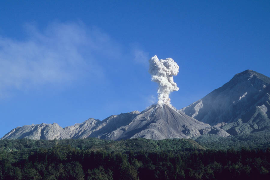
Santiaguito
Santiaguito is not actually a volcano, but an active and presently growing lava-dome complex on the south-western flank of the Santa Maria volcano. Located in Guatemala, it has been continuously erupting since 1922 which is an exceptionally long time for a dome complex. The dome growth has been accompanied by regular small vulcanian explosions (like the one in the image above), occasional lava flows, larger explosions, pyroclastic flows, and lahars. It's seemingly endless activity makes it an ideal candidate for research as it is one of the few volcanoes in the world which it is almost guaranteed to be still erupting during fieldwork. Perhaps surprisingly, there has never been a permanent seismic network installed around this volcano although there have many temporary networks deployed in the past. Edit: As Rudigar has kindly pointed out in the comments below, it seems I got this wrong. There is in fact a permanent deployment and you can see them here (stations STG2, STG3 and STG4). I will hopefully be getting some data from a new network to be deployed in the later half of this year!
Mt Unzen
Mt Unzen, also known as Unzen-dake, is located near the city of Nagasaki on the south-western end of Japan. It's last eruption began in November 1990 with a series of large explosions. They were followed by prolonged dome growth from the summit, eventually ceasing in February 1995. Partial collapses of the unstable lava dome meant that over 9000 pyroclastic flows were produced over the course of the eruption (Nakada et al. 1999). Sadly, one of these pyroclastic flows was responsible for the deaths of 43 scientists and journalists who were watching the eruption, including the famous french volcanologists, Katia and Maurice Krafft. From this eruption, I am focusing on the last few months of the eruption when a new lava spine came out of the top of the dome. By analysing the seismicity during this period I can hopefully help with understanding the processes during the formation of these features.
Mt St Helens
Of all the volcanoes here, Mt St Helens is probably the most notorious. It's May 1980 eruption was the deadliest and most economically destructive in the history of the United States. Ever since that eruption, the volcano has still been rumbling away. It's most recent activity was from 2004-2008 where it experienced multiple explosions (smaller than the May 1980 explosion) and then constructed a new lava dome within the 1980 crater. It's seismic data from this period of activity that I will be focusing on for my project, particularly as multiple lava spines were made during this eruption. On a personal side note, it's this volcano which, during a 1999 visit, so amazed my 8-year old self that it later inspired me to consider studying volcanoes as a job. My present-day self is delighted that I've come full circle and is actually carrying out original research on this very volcano.
If you have any questions or comments about anything I've written here, please feel free to get in touch. I always appreciate any kind of feedback! Thanks for reading.
Luhr, J.F. & Carmichael, I.S.E., 1980. The Colima Volcanic Complex , Mexico: Part I. Post-Caldera Andesites From Volcan Colima. Contributions to Mineralogy and Petrology, 71, pp.343–372.
Nakada, S., Shimizu, H. & Ohta, K., 1999. Overview of the 1990 – 1995 eruption at Unzen Volcano. Journal of Volcanology and Geothermal Research, (May 1991), pp.1–22.
Volcán de Colima
 |
| View of Volcán de Colima from the north-west in August 2012. The large lava flow in the foreground was formed in 2004. |
Santiaguito
 |
| An explosion rises from the active Caliente vent at Santiaguito (Taken Dec. 2005, Source: photovolcanica.com) |
Mt Unzen
 |
| The view from the east of the 1991-95 dome at Mt Unzen, taken July 2013. Some of the pyroclastic flow deposits from the eruption can be seen in the foreground (Credit: J. Kendrick). |
Mt St Helens
 |
| Mt St Helens, September 2008. The 1980-86 and 2004-08 lava domes can be seen inside the May 1980 crater. (Credit: J. Kendrick) |
If you have any questions or comments about anything I've written here, please feel free to get in touch. I always appreciate any kind of feedback! Thanks for reading.
Luhr, J.F. & Carmichael, I.S.E., 1980. The Colima Volcanic Complex , Mexico: Part I. Post-Caldera Andesites From Volcan Colima. Contributions to Mineralogy and Petrology, 71, pp.343–372.
Nakada, S., Shimizu, H. & Ohta, K., 1999. Overview of the 1990 – 1995 eruption at Unzen Volcano. Journal of Volcanology and Geothermal Research, (May 1991), pp.1–22.
I enjoyed reading your blog and look forward to hearing about your on-going research. being a novice in the world of volcanic study I found the post fascinating and intriguing.
ReplyDeleteThank you Hazel! I'm excited to start this blog and to see how it develops.
DeleteNice project! I wish you the best luck with it. I just had a few comments and questions on Santiaguito. When you say that Santiaguito is not a volcano, what do you mean? I guess you could say Santiaguito is part of a larger volcanic system that includes Santa Maria, and a dome complex, with different dome units, but I'd still consider Santiaguito a volcano in the broader sense of the concept. But who cares, it's just semantics, right?
ReplyDeleteRegarding the seismic monitoring of Santiaguito, what do you mean when you say "there has never been a permanent seismic network installed around this volcano although there have many temporary networks deployed in the past"? Seismic equipment has been installed near the volcano since at least the 90's, and since 2005 INSIVUMEH, with support from CONRED and the USGS installed a 6 short period seismic network. Although some of those stations are not working properly at this moment, at least 3 are still working and can be accessed online in near-real-time here: http://www.insivumeh.gob.gt:8060/ (stations STG2, 3, and 4). In any case it seems unfair to say that there has never been a permanent seismic network installed around Santiaguito. This network probably wouldn't be very useful for what you're doing because these are short period instruments and I'm guessing you want to look at broadband data, but from the general perspective of volcanic monitoring, short period networks have been (and still are in most places) the standard for monitoring. I hope the instruments you plan to deploy and the data you will be collecting will also build on the work of other people, both Guatemalans and foreigners, who have studied the volcano for many years. I would also encourage you to interact as much as possible with the local observatory and with the INSIVUMEH staff, and if possible share your data and results with them and encourage them to use that info! I suspect they will play a key role in your logistic arrangements anyway, so it would be good if they can see the value of your work.
When are you planning to do your field deployment?
Saludos!
Thank you! We could spend a long time debating about what exactly a volcano is. As you say, it is just semantics.
DeleteThank you very much for the link. It seems I had been misinformed by certain people when I had asked about the seismic networks around Santiaguito. I'll edit the post and add the link. You are correct when you say that I will need broadband seismic data, but it would be nice to also have the short-period data alongside. I never intend to step on anyone's toes, so I will check to see what has been done already before I begin my analysis. From the start of this project, I have always hoped that my research would be useful for the scientists observing Saniaguito and other volcanoes worldwide. I would be more than happy to present to the local observatory and anyone at INSIVUMEH. Amny advice or contribution from them would be invaluable.
No solid dates for field deployment yet, but it will not be before the upcoming rainy season. Hopefully we can begin deployment in September/October/November.
Cheers!
Yes, from what I know several groups are involved in doing fieldwork and collecting data in the area for various research projects, but most importantly is to coordinate your field trips with the local observatory and INSIVUMEH.
DeleteIf you want to avoid the rainy season you should aim to go between November and May, so not much time left before the next rainy season. September is usually the most rainy month, and October still gets a lot of rain, and if you plan to work "on" Santiaguito you probably want to avoid rainy weather (it can get really complicated and even dangerous). In any case, good luck and keep us updated!